|
[Slide1] Thank you Ladies and Gentlemen.
[Slide2] What I want to do this afternoon is to give you a brief overview of why in England we have ended up in transport planning, in trying to embrace the strategic environmental assessment, and of why from the transport planning approach, SEA can make good sense. I then want to give you a little case study, which is actually dealing with a very large portion of England, called the Southwest Area Multi-Modal study. I'll then touch on a motorway-widening project where the exercise was to try to define the road project within a very narrow corridor. And finally I want to give you a few insights into some of the issues that have arisen on the implementation of SEA.
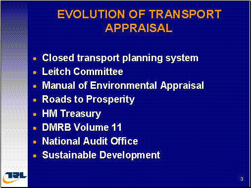
[Slide3] So turning to the time of the evolution, perhaps during the 1970s, the UK transport planning process, with much closed exercise with the public, did not really have opportunities to get involved except through local protest groups, so they engaged in processes of making the public inquiries very long, very delayed and having a high amount of public disruption. But what we did do which caused the government to review its approach to building roads and that lead to a new select committee, lead committee, which actually caused a new approach to evolve and this was to be recognized with more building has to be moved from just a monetary evaluation towards a more comprehensive framework in which they brought together all the factors and the different groups of people that were likely to be affected by the scheme. And this was in 1977. It wasn't however, until six years later that the actual guidance emerged, in terms of the manual for environmental appraisal. And during this period, there was still very much a separation, a separation between the environmental assessment activities, the technical, engineering assessments and the financial assessments of the projects. And there was a big risk that the environmental information was given a relatively low weight in the decision making process. The emphasis was very much on predicting and providing. They would predict the new infrastructure that was required. They would then provide it, and of course, the traffic grew to meet that new infrastructure, was entirely driven by approach towards economic efficiency. During the late 1980s, we decided we will have a very big road-building program, under this type of white paper. By the Thatcher era, building roads to create economic prosperity, we got to spend something like six billion pounds. However, this then created a large amount of public concern. Many, many public protests, and there was one very important scheme that the government spent thirty one million pounds on developing only for it to be abandoned because of the public protests. So as a very real tension taking place between what government thought it was needed to deliver and what the public really wanted and then how much this treasury tend up to be an important player in the evolution of transport planning. The treasury produced a guidance document called the green book. This book gives advice on how to do assessments of non-monetary subjects. It seeks to provide a common methodology, a common requirement, across all of government departments. And so the Transport Ministry have to take on board this new advice from the Treasury and it set about trying to produce new tools and techniques to address non-monetarized values. Eventually, this led to an environmental impact assessment guidance manual that also picked up the EC directive on EIA. And this was beginning of the first part of integrated planning, actually trying to bring the environmental assessment processes into the highway design process and more importantly, the design manual for roads and bridges, also had key requirements for public involvements and to stakeholders consultations, and these were throughout the design processes of the road. The government also, at this time in 1993, changed the rules for public inquiries, so that it would allow anti-road campaigners more access into the transport planning process. So we changed from a closed system to be much more open in our transport planning activities. Then money got tight and the Audit Office said we couldn't possibly afford to build all of these roads. And more importantly, it said that it wasn't the environmental capacity to build all these new infrastructures. And we could not meet all of the anticipated demands, predict and provide which date so we need to find a new approach. And long came sustainable development and that helped changed the attitude towards transport planning. Transport was seen to be there to meet the economic and social needs providing access to facilities and to reduce the need to travel where given an acceptable impact upon the environment. This was quite a radical change from just predicting what you need and providing it. We also had change of government when the Levi government came in that led us onto a very much approach. An approach where local people were to be involved in the transport planning processes and businesses were to have a real influence over what transport was provided for them. And the government set about change in the entire process of transport planning.
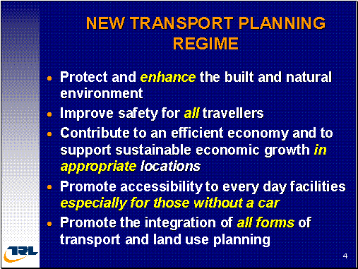
[slide4]Fundamentally, it introduced five broad objectives which transport projects have to deliver. I have highlighted in yellow, the key words for you. I think, importantly, its an emphasis upon all travelers, not just motorized users, promoting access for those, especially for those, without access through a car again stimulated a big change in the approach to transport and transport appraisal.
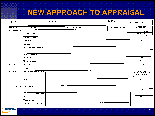
[slide5]This then required some new thinking about how this information was actually going to influence the decision making process. And what was generated was the Appraisal Summary Table. This is the vehicle, by which the main economic, environmental and social impact of the transport strategy or measure can be made clear and presented to the decision-makers. It doesn't provide the judgments about the relative weightings of the individual impacts but it just provides the mechanism by which the decision makers can be aware of the issues. So we have the environment here with a number of subjects, noise, air quality, greenhouse gases, landscape, townscape, biodiversity, etc., safety issues, economic issues, accessibility issues and integration. So we have environmental issues, safety issues, economic issues, accessibility and integration. And integration was particularly important following from the sustainable development agenda which was integration of transport roads, integration with land use policy and integration with other government policies, the extent to which transport strategies actually helped deliver similar other government policies. And you see this space for qualities of impacts and space for quantitative descriptions and this column is used for the assessment score. This was a revolution in the way that information was presented to decision makers. Previously, it was lots of reports of very simple overviews. So we have a transport problem but we didn't have the money to be able to spend on building new roads, it wouldn't really solve the problem. We have this new agenda called integration. So this identified a need for a new approach to transport planning. And this was essentially called Multi-Modal Studies.
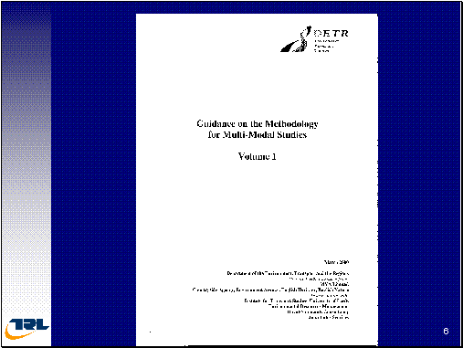
[Slide6] And then the guidance was prepared, Guidance on the Methodology for Multi-Modal Studies. And this set out four key requirements for transport planning, not just the appraisal summary table.
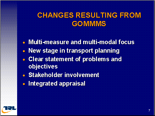
[Slide7] Which you have seen but also it required that in developing a strategy. There was a need to evaluate its performance against local and regional objectives that was specifically established during that study. That the assessment should report the extent to which the problems are actually being resolved and there also should be, what was called, a set of supporting analyses and these supporting analyses was to address issues of distribution and equity: who were the winners and the losers, issues of affordability and financial sustainability. Can we afford to deliver it and can we afford to keep delivering it over a long term? Is it practicable and will the public accept the propose measures? So this guidance really changed the approach to transport planning and it provided a perfect seedbed for strategic environmental assessment. So as part of my work, which actually use this guidance manual, which essentially being based upon some project level assessment techniques and revising it to provide strategic environmental assessment methods and techniques. And this guidance is now being used for about twenty four multi modal studies across England. So it requires both a quantified and a qualitative approach to decision-making. It seeks a very clear understanding of what is the problem that you are trying to address. A good review of alternatives, including very radical alternatives, if you so wish, but that's the theory, now let's go to the practice. Some of the benefits from GOMMS were multi-modal focus, multi-measure focus, with new stage in transport planning before the project. I have already said that it needed to have a clear statement of problems and objectives. It also required stakeholder involvement throughout the exercise. That was again a key part.
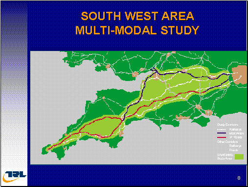
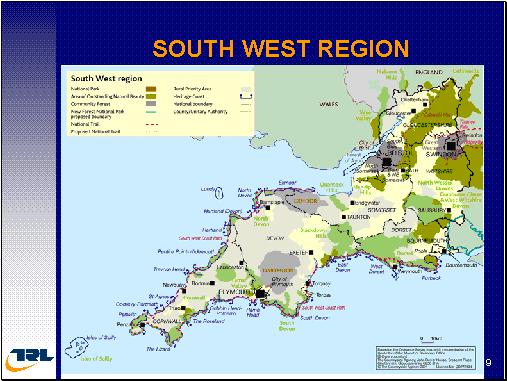
[Slide8] I will explain about the practice. It is about The South West Area Multi-Modal Study. That was a large portion of England. And this area contains very important landscapes.
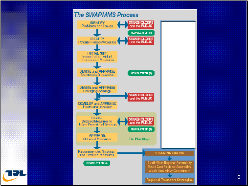
[Slide9] We have national parks and we have areas of national landscape importance. We also have very important coastal areas. Fundamentally, this is an area with high tourist activity. It is also a peripheral economy and suffers from poorer transport links to the rest of England. So the study was about trying to address and improve the transport problems in this area to provide for the tourism and fundamentally to try to provide more jobs and to improve the access of this peripheral economy to the central economy in the southeast. The SWARMMS Process basically followed the core that is set out in the Guidance Manual for Multi-Modal Studies.
[Slide10] First of all, beginning with an understanding of what are the problems and issues and with the public and key stakeholders having an involvement in that exercise. The next step is to identify what are the potential measures, the potential solutions that can be brought to bear. Again, public involvement, in suggesting transport solutions, an initial shift to remove those which are not ever going to be deliverable for whatever reason to then generate a series of strategies. These are then evaluated, again with public input and with a preferred strategy were then prepared. In this particular approach, detailed transports measures were then defined that will help deliver that preferred strategy. A detailed appraisal undertaken a recommended strategy, there was a steering group established to oversee the study which lasted about 18 months and cost about 1.5 million pounds. But as there were three levels of three different areas of regional governments to be involved, the most important being the South West Regional Assembly. These, two at least at the top, the South West Regional Assembly and the South East Regional Assembly, have responsibility to prepare regional transport strategies and this guidance was to help them undertake that activity.
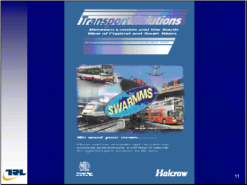
[Slide11] But behind all of these are the Department of Transport and the Treasury who hold the pull strings for the delivery and acceptability of the recommendations that emerged. A very high profile was adopted in providing access to the public: internet sites and lots of newsletters, and one of the issues that they had was how to get the public to actually think strategically, to think about the big picture rather than being concerned about their own local problems.
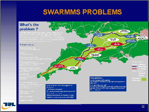
[Slide12] At least this was part of the illustrations that went in the newsletter just identifying whether it was some congestion or whether it was a safety issue, these sorts of things, just to help create an image to the public. The public provided inputs to express views to what the issues were after the stakeholders and various public meetings that were held. These measures that were identified were then fed together to make a series of broad strategies that ended up with four alternative strategies.
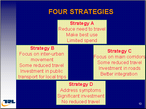
[Slide13] This was effectively, making best use, Strategy A). Strategy B) focused upon inter-urban and some public transport. Strategy C) focused upon inter-urban and roads and Strategy basically doing a predict and provide. You are not attempting to manage demand. You just have lots of investments in new infrastructures. Behind that, there was then a whole series of different themes of transport measure.
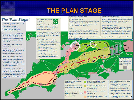
[Slide14] So, in this box we have measures to reduce travel, integration and transport, provision of public transport, provision of rail infrastructure, rail freight, information technology, rail safety, road safety, whole series of different approaches that could contribute towards building a strategy was set out and this again was part of the exercise of trying to communicate these issues in the complexity to the public and get them to participate as to which type of package of measures they have preference for. SWARMMS led to a series of more specific plans, once to be identified its broad strategy. They developed a series of plans. These plans provided locally relevant measures, transport measures and policies.
[Slide15] These were for two urban areas and then for four corridor areas. And there were four themes, across the entirety of the study area. And these four themes were for inter-modal freight, tourism, and real access and reduced travel. And this is just the diagram to show the level of detail to which they got.
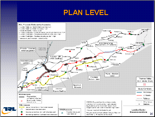
[Slide16] This is one of the study areas identified where improvements in the real services were needed or where widening of the road capacity was going to be required.
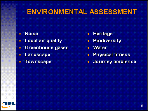
[Slide17] The environmental assessment was undertaken against the usual, usual headings, but again, we have both quantitative and qualitative measures.
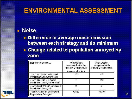
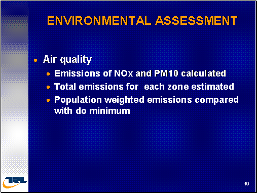
[Slide18] This one, looking at noise, took a very much zonal approach to the city area and identified the change in the number of people who are likely to be annoyed in terms of the number of zones when you compare each of the options with the present day as well as what the situation would be in the future if it was to do a minimum. And then they made calculations; they made estimates of the number of people who will likely to be affected by this increase in noise. And they did the same thing for air quality.
Skip [Slide19]
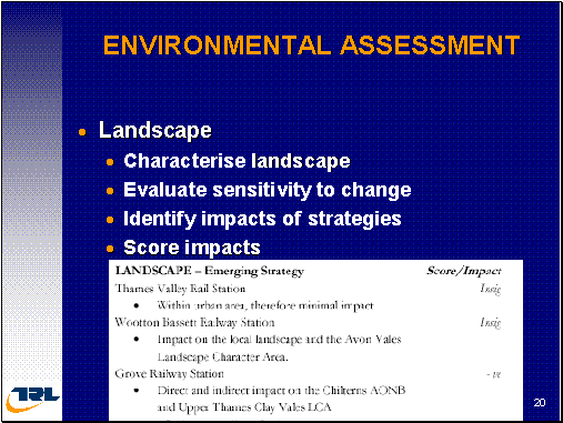
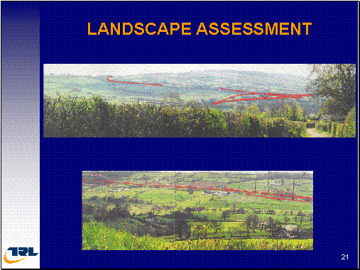
[Slide20] In terms of landscape, the framework was subjected and the guidance required them to characterize the landscape to understand what was there and what was important and why. To understand how sensitive that environment was to change and then to identify the impact that the strategy and its component measures would cause.
[Slide21] This little table at the bottom shows you that for a particular new railway station that they were proposing that was going to have an insignificant impact on the landscape whereas the subway railway station at the bottom, they viewed as having a negative impact. Thought I have to give you some pictures of Cornwall so you all go there and have your tourism in Cornwall but very nice, nice area and again just some images of where some of the transport projects were in tract with this area of national landscape importance.
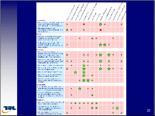
[Slide22] Communication with the public, I keep saying, was a key activity, but also an area which distortions can be introduced. In these, we have the various possible transport activities such as enhancing the rail corridors or improving road infrastructures. This was a way of communicating issues to the public, with you know, green stars and red dots for problems. You'll see that the environment has just two columns, two rows, economy, I think, six. Creating a sort of bias and some of these subjects in here were actually self-fulfilling. So a bit of distortion goes on and actually communicates with the public here.
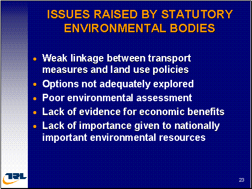
[Slide23] And because this area was so environmentally sensitive, the environmental bodies, discussed the three environmental bodies commissioned me to look at these environmental, strategic environmental assessments and to make comments to help them put a case to government as to why or what the environmental issues were from their perspectives. What we found was that there was a very poor relationship between the transport measures that were being proposed and the land-use policies. Despite the call in the guidance for improved integration, it actually wasn't happening.
[Slide24] The different transport options, which were available, were even though, there be an extensive public involvement, it was almost as if that being put in the bottom drawer and forgot about. They began to concentrate on the tried and trusted approaches. So there was a lot of disquiet about some of the measures that were actually included in the strategy and particularly as to why they were presented to where they were. The environmental assessment was poor. I showed you just those scores of minus, negative, positive or whatever that was presented. There was no basis for which one can understand externally as to why and how they derived those answers. And in many cases, looking at it from the outside, we would come to completely different views. So the assessment wasn't robust. It didn't have a buying from the other stakeholders. But fundamentally, there was a big political agenda here. I said the Cornwall was a peripheral economy that relied upon tourism. So it was a great political imperative to be seen to be providing for jobs. And the old agenda has been, if you build more infrastructures, more transport infrastructure, which provide more jobs. The last view is being roundly challenged by the standing committee on truckload appraisal sector. And the argument here was simple that building roads would create jobs in the peripheral economy. That hadn't been proven. What was proven was that it would have pretty dramatic impact upon the landscape that the people are going there to enjoy the tourism. So we have, on the one hand, a belief for transport providing economic development versus the certainty of the environmental disruption. And this was a tension that the assessment didn't address. It generally undermined or underplayed the importance of the national landscape ecological and heritage features in the study area. It was perhaps too dominated by a transport agenda.
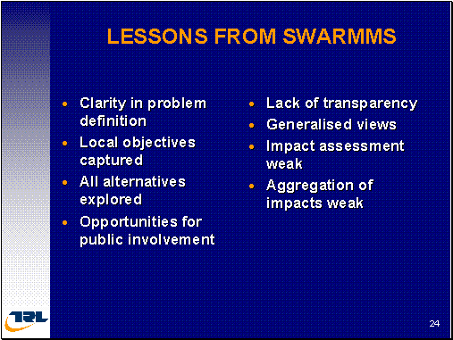
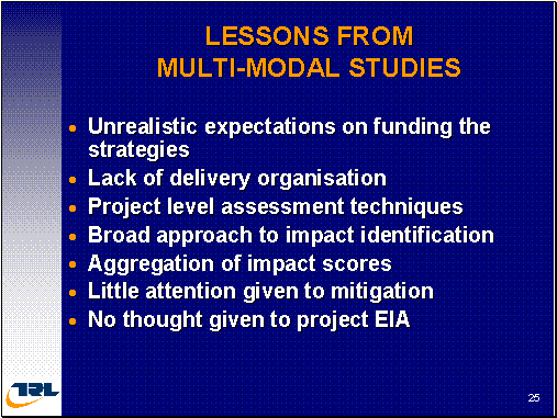
[Slide25] So what were the lessons that we can learn from these. The good point was to have a pretty good understanding of the problem that result to capture local objectives. I take you all of that now. They looked at many alternatives and didn't necessarily look at some of the alternatives that the statutory body adviser we would have liked them to have examined. And they provided very good opportunities for public involvement, but perhaps, to follow through of showing how the public involvement was actually captured and influenced the assessment process wasn't really shown. Fundamentally, the assessment suffered from being not very transparent. It wasn't easy to see how they had arrived at their strategies. It wasn't easy to see why particular transport measures were in and others were out. It wasn't easy to understand why they were given particular impact score to a particular situation in one place and a different score for what would be seen as the same impact in another place.
Few issues. There was also a great tendency to average the scores down to give the right story. And so this process of looking it all the individual impacts and trying to provide an overall score is a way in which the balance can be distorted and their study to some extent suffered from that.
The wider lessons from the Multi-Modal Studies, the Multi-Modal Studies ended up with very big budgets in terms of the transport measures, policy changes that were going to be required. And when they added it all together, the government didn't have the money to deliver these transport strategies. Fundamentally, being an integrated approach to transport, there was no integrated approach to delivery. And the rail sector basically doesn't have the money to play its part in the transport solutions. So the strategies that were being developed in the main turned out to be unrealistic with essentially only road building agencies being able to deliver. So we are actually going back to delivering roads rather than an integrated transport solution so the lack of mechanism put in place. Some of the measures that were identified in SWARMMS were to deal with tourism or were to deal with rural transport. But there were no organizations there that were actually able to deliver those recommendations. So they were kind of left hanging. The Multi-Modal Studies were using project EIA type techniques and when you are dealing with large study areas such as these, they quite plainly don't work. So the consultants were then using best guesses and again these led to problems of transparency when the assumptions and the bases on which those judgments were being made weren't being then provided in a clear way. Their approach to assessment and impact prediction wasn't focused. It didn't address the big environmental issues about the national landscape and ecological values that these area has. And as I said previously, the approach to adding up all the individual scores wasn't clear and often showed some bias. Despite the transport measures being in areas of high environmental sensitivity, there was no specification given to what mitigation measures would be required. In principle, there was no recognition, no thought, as to what this would mean for the environmental impact assessment of the project that they were recommending. They weren't taking the opportunity the opportunity that SEA provided towards they provide the terms of reference for the EIA to be able to advise which subjects don't need to be examined any further and which ones are the real issues to examine.
So the concept was good, but the delivery, the implementation has been was somewhat poor. There is presently a big review-taking place to try to learn the lessons from the Multi-Modal Studies. We believe this is going to be reported later on this year. But while there've been problems, it has been very clear that a change of attitude and a change in transport planning is now going to stay and we will have improved guidance and we will be learning from these lessons.
[Slide26] Quite quickly now, I want to move on to a motorway widening project. This is the M6 Motorway between Birmingham and Manchester. This particular section, some, my part of the study, this was 53 kilometers long. And this was a motorway study that I undertook in the 1990s. What we call this type of study is Stage II assessment study. This is a level of assessment that enables one to choose between alternatives and normally, when choosing between alternatives of different corridors, but with the motorway widening study, we've got our corridor that's given. So our alternatives we're looking at different ways on which one can widen the motorway. So we have a very well-defined transport corridor. But we have a not very good definition of what widening activities are going to be. And the objective was to be able to advise as to what was the preferred widening strategy and to provide confidence to the minister that a scheme; a project could be delivered without causing undue public anxiety. In order to conduct this Stage II assessment report, we looked at the corridor five hundred meters in the side of the motorway and gathered existing environmental information together to a series of consultations with the local authorities and statutory environmental bodies. We did not undertake any detailed field service but we did explore the territory. So we had a basic environmental understanding of what was there.
I am not to going to go through this in detail. You've got them in your slides but effectively we had seven different widening strategies ranging from symmetric ranging from narrow lanes.
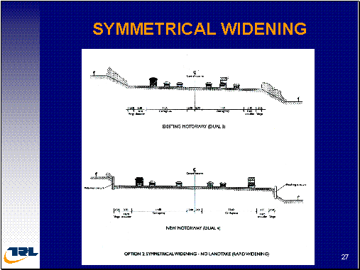
[Slide27] Symmetrical widening with no land take.
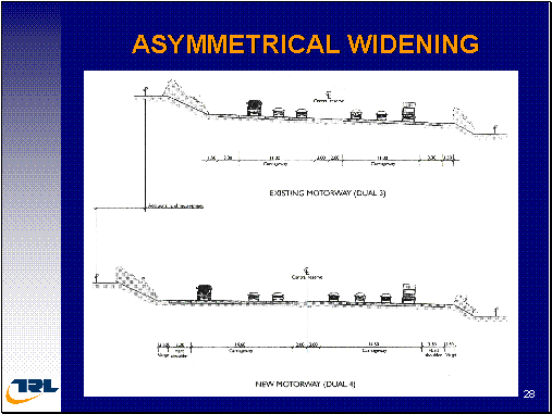
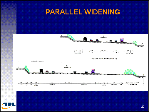
[Slide28] Symmetrical with additional lands. There was also parallel widening; where one builds an entirely new four lanes separate.
[Slide29] and then you have this lane abandoned into environmental medication on this position to use as an emergency facility. This was called parallel widening. We also looked at a series of offline solutions as well as what we call a collective distributor which would run after fifty meters on either side of the motorway as slightly road laid road that will link junction to junction because a large portion of the traffic was through traffic taking from London ultimately through to Manchester and beyond.
So we examined the environmental characteristics and we had to make various assumptions as to what these different widening strategies would mean. So we had to make an assumption as to how much land parallel widening would be. And an approximate view of what would be the additional land that would be needed to construct and the sort of embankments of coatings that would be required. So with our engineers, we had to make a set of assumptions that we then applied to our understanding of the environmental features of the corridor.
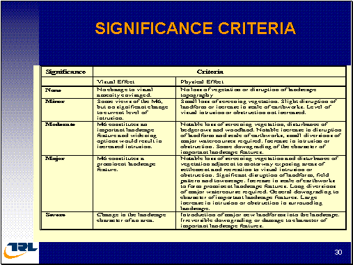
[Slide30] And the environmental features, we had to rank them in terms of their environmental importance and their significance, in terms of how our assumed impact, our assumed activities, they would associate with each of each of the widening strategies. How these would affect the different features. So we ended up with, in this particular case, a five point score as to whether we assumed that the feature would be moderately affected, major impact or severe impact. We generated this kind of criteria for each of the environmental topics to provide us with the framework. A framework by which we were then able to make trade-offs, trade-offs between the various features that occurred on both sides of the motorway.
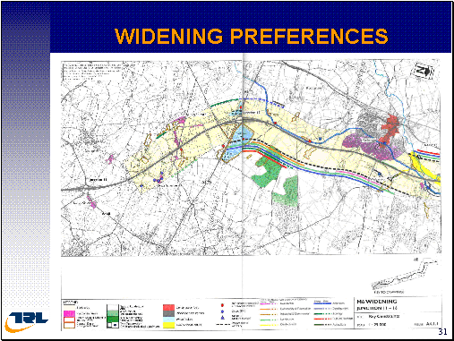
[Slide31] And as you can see, just through this map, for each subject, we ended up with a view as to which side we had a preference for because of the environmental constraint on the opposite side. And in some cases, as when there is a solid line, this is a very strong preference. There will be some moderate or major or even severe adverse effects if one went on the opposite side to do the widening. Whereas if it was a dotted line, it was a preference but it was not particularly strong because one could do some mitigation to address the problem. And you can see that we also had situations where we have to make trade-offs between a preference to be on one side and a preference to be on the other. And also a preference that occurred that changed along the length. So this entire study was one of mapping out the environmental risks and preferences from one, from widening on one side to the other and also making judgments as to what type of widening was going to be preferred.
Now, generally from an environmental point of view, one would say, a widening strategy that takes a least amount of land would deliver the least environmental impact. However, that wasn't the case in this project because there were many places with properties very close to the motorway already experiencing fifty, sorry, already experiencing about seventy decibels. And so by moving the motorway twenty five meters as a result of parallel widening, some significant acoustic benefits could be delivered to local residents. And so we were then into situations on how to make a trade-off between the acoustic and air quality benefits to the people, perhaps, and against the ecological or archaeological or landscape impact, from the side that would be taken for additional land.
I think the main conclusions from this study was (sic) that the process of doing this assessment didn't require a project level of data, didn't require a covering of all of the environmental impact subjects. Only those that were crucial to the making of a choice as to what type of widening was necessary. So drainage issues weren't examined. Some issues such as archaeology, we had to make assumptions as to where the archeological risk was going to be, whether there were known sites. We had to define buffer zones of what might be its boundary. And these were all established with the stakeholders and the statutory bodies so that they understood why we were making the trade-offs. And in some situations, we were trading-off ecological sites, on one side versus ecological sites on the other. And we had to that with the assistance of the English Nature, the body responsible for ecological sites in England.
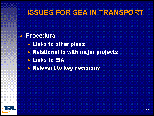
I want to close by bringing together a series of views as to what are the issues for SEA in transport as I see them from a UK prospective. These can be grouped into three categories. There is the Procedural Type of issue, there is Technical and then there is Cultural.
[Slide32] I think in terms of procedures; there is a question of how we actually link the transport SEA together with other plans, particularly land use plans. Recognizing that such plans may be prepared over different spatial scales, different administrative boundaries, to perhaps different time scales, so we have a big issue on how to coordinate and to link land use and transport planning processes. We also need to link between the transport plans and say the house plans or the school plans. So the transport actually plays its part in meeting the needs for those sectors. And if you think about it, moving away from this closed transport planning agenda that we had in the early seventies towards an agenda now were we're thinking how this transport actually deliver better health care, how this it help our education, it's quite a radical change and it means that the organizations also needed to change. It means that the organizations need to become more permeable. They need to be less concerned with preserving their own domain and recognized that the wider community benefits did actually come from working together in partnerships. It also might mean that we will see situations where mitigation measures are delivered by different projects to the one that actually causes the impact. Then, we actually might see environmental mitigation being undertaken in a way that has improved environmental performance instead of delivering only scheme-by-scheme basis; we deliver mitigation in a wide area and basis. So, on these procedural issues, we can think about how we organize the delivery of environmental mitigation.
I think also the key issue is how we can make sure that we don't have some real problems, that we don't cause analysis by all those expert, don't cause some paralysis by all those expert analysis that we are going to undertake. That we must make sure that the delivery of major projects and their EIAs has speeded up. SEA should be set out in a linked way with EIA so that the whole project delivery processes may be more efficient. Otherwise, we are going to end up with a political fallback. Say, this assessment, it does not help. It is getting in the way, it is slowing down the delivery of the solutions that we need. And we are already facing a lot of pressure to speed up in England. So fundamentally, we have to end up with procedures for SEA that are actually relevant and timely to the decision making processes. Otherwise, as I see it, it will be seen as a burden.
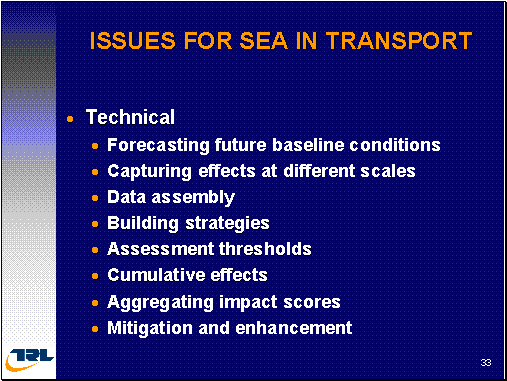
[Slide33] Moving on to the technical side. We've got to make forecasts in transport for often twenty, thirty years, hence, it takes us ten years to get a road built, maybe longer for a railway. While the uncertainties in transport forecasting are one thing, with SEA it brings another added level of complication. Trying to forecast the changes in transport technology, clean the vehicles, multiple use vehicles, different ways for use vehicles, different technologies in managing the transport network, let alone, changes in the environment, land use and populations. So we've got some more issues to grapple with as to what is the future that we are going to be having in our assessment. And the assessment therefore needs to be sufficiently robust that they can withstand changes for the next level of events, whether it be a big factory or big employer closing done or a change in the price of fuel. We need to be aware of the different scales that we are dealing with. Transport produces benefits at the local, regional and national scale. It also produces these benefits, particularly, at the local level. And to be able to organize both the technical and the decision-making processes, the political processes that account for these differences in scale can be quite a challenge. There is also a danger that we seek more and more data or alternatively, the danger is, going the opposite, that we've gone too far simplistic in the approach, such as the answer isn't robust. And if you get to the project level, then we will find that the conclusions that were reached at the strategic environmental assessment were not robust nor correct. And that could then cause an awful lot of delay and confusion at the project delivery. So we need to get the right balance of data. The way in which strategies, alternative strategies are built creates opportunities for bias. We need to improve the guidance on how to put together strategies to ensure that the process is always transparent. And particularly for dealing with a large study area such as SWARMMS, we need some assessment thresholds by which we decide that's not going to be an issue or we don't need to look at that because it falls beneath a threshold. But that then challenges the subject of cumulative effects where impacts that occurred beneath the threshold are ignored but collectively, they may actually be important. And there is a desperate need to improve the guidance in this area. Similarly, we need to improve the guidance on how to aggregate lots of individual impacts so we could write an overall score. And lots of new opportunities associated with mitigation and enhancement that were available through strategic environmental assessment where we can be considering measures that extend beyond the narrow boundaries of the project. Potentially also involving the creation of new institutions, new organizations to deliver the strategies, to deliver the environmental objectives.
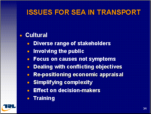
[Slide34] However, to conclude the hardest part, is dealing with the culture, the cultural change that SEA will require. As a large number of stakeholders that would be involved as we have more subjects, as we have a larger area so we are dealing with stakeholders with different coalitions of interests that actually shape policy. And we have to find a way in which we can handle these in an effective manner. We talked about the public many times but how to get the public engage when you got a large study area and when the projects are so, so remote from them is an uphill challenge. We need to ensure that our transport planning people focus upon the causes of the transport problem rather than just the symptoms in terms of congestion and I think, we are beginning to turn that that one around. And as we bring more and more recognition the transport has to deliver against all objectives, so we end up with more and more conflicting objectives on having to find institutional and cultural ways by which to make these trade-offs. The economic appraisal is changing. We are becoming concerned about not wasting scare resources. And I also … I already mentioned that we spent thirty one million on a road scheme only to have it abandoned because of environmental and public concern. So value for money is driving the need for a robust appraisal scheme, an evidence-based appraisal scheme. We've got a lot of complexity and it'll be a lot more complex but as we said earlier on, we have to find a way to simplify, to make it understandable. Otherwise, it won't be understood by the decision makers. And we need to think very carefully about how the decision makers interact with SEA. They could see this as a tremendous challenge to their authority as it draws a greater spotlight put on the processes which were previously vague and not very clear as SEA shares the spotlight, so their ability to make judgments and to make decisions may be more questioned by the public. And fundamentally, there is a need to think about the training. We need to deliver this culture change through the development of yes-new chosen techniques but having them as a guidance document is only the easy part of the exercise. The hard part is getting inside of the minds of the people doing the assessment and the people receiving the reports in order that they can fully understand its conclusions. Thank you.
Questions and answers:
We go to baseline conditions for the future. You cited that as technical challenge. Now, to improve your road or road system in the future, noise and atmospheric pollution has to be estimated but then you also have to look at the future population along the road. What methodologies do you use to estimate the population and demographics along the road which might be affected in terms of environment pollution and noise?
The key question is the point in the planning process that we're up with this plan. If we're talking about a long-term plan that's being assessed that does not arise in twenty, thirty years, then we have some different issues to deal with and if we are dealing with the plan, this one has got a fifteen year horizon. The reason being is that our land use planning system currently has a planning horizon of about fifteen years ahead in which it is made a broad allocation of where the housing is going to be. When you go beyond that, there is no real; there is no assignment, of where this population is going to be. So you have a situation where there is a need from the transport planning to be kind of ahead of where the land use planning agenda is got to. I think that's part of the tension that will emerge in the future. The way that we do it is we use the land use plan to deal with the certainty in course of the land use change that the plan forecasts. So we notice where the housing allocations are going to be. Using the senses information as well, we know those areas and their growth rates in terms of population. Each region has a housing allocation. It is told that it has to provide X thousand houses over periods of time. So that gives us an understanding of what's happening in the corridor. Period beyond, it is just a pure guess in terms of the rate of growth that the National Treasury would apply rather locally derived growth. And you are not able to assign that to specific points. You just need to agree with pro-rata in terms of population that can be identified for the extended period. |