|
[Slide1] Ladies and Gentlemen, good morning. I am very honored and privileged to be in the position to discuss with you the practicalities of strategic environmental assessment. I think Barry Sadler just give you an excellent overview of what could be a theoretical framework for SEA. Right now I will try to get into the practice of what methodology is used to carry out an effect of SEA in practice. And I will try to do that by discussing with you two case studies that recently were undertaken in the Netherlands. One of them is on special planning and the other one is on sectoral planning about waste management. Now in the time available what I will do, I will go through the special plan SEA in great detail and then I will highlight some aspects of the SEA that has been carried out for waste management planning. However, in the research report that the Japanese government is currently preparing, you will of course on both case studies have full information including four extra case studies from the Netherlands on energy planning, on water planning on regional spatial planning and on the planning of minerals extraction.
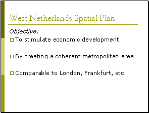
[Slide2] Let me start by the first case study, this actually was a strategic environmental assessment that was carried out for a huge spatial plan for the west of the Netherlands. Now the western part of the Netherlands is the part in which our main cities are situated. For example, Amsterdam the capital of the Netherlands, Rotterdam the world's biggest harbor, the Hague the capital of government and Utrecht, the fourth biggest city in the Netherlands. Also the majority of economic development takes place in this part of the Netherlands and the overall and the most important objective of this spatial plan was to improve the economic competitiveness of this part of the Netherlands against the areas like that in the countries around the Netherlands, more specifically the London metropolitan area, the Paris metropolitan area and the German area around Frankfort. So the objective of the spatial plan was to stimulate the economic development as much as possible by creating a coherent metropolitan area. Basically what this spatial plan tries to do is to change the existing four cities into one big super city. Actually it changes the four cities into one big urban area that operates economically as one efficient unit. And all of these are meant to be able to compete economically better against comparable regions in low and Frankfort.
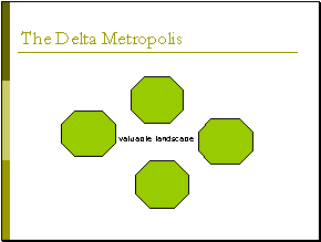
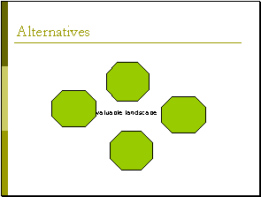
[Silde3] Now, from these pictures first of all you can conclude that I am not a very good geographer. This is a very bad map. Of the west of the Netherlands, actually what you see here is a very rough schema of the four major cities. On the top you see Amsterdam, to the left you see The Hague, on the bottom Rotterdam and to the right Utrecht. This is just to show you what we try to do in the Netherlands. We try to link the cities in such a way that a ring of urban areas created with a valuable landscape area in the middle. This landscape area is very important in the Netherlands, because it is the main area for the recreation of the citizens of these four cities.
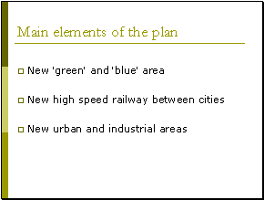
[Slide4] I already told you the main purpose is to create a new super city. Now, how is this spatial plan going to do that? Basically, there are three main elements of the plan that contributes to the quality of the area. The first one is the creation of new green and blue area. What I mean here is green area such as nature area recreational area and blue area such as water area, rivers and lakes but also folders to prevent the Netherlands from flooding and of course you know that this is a significant problem in the Netherlands. We feel it is very important for an economically competitive area to have very good nature, recreational and water area because international companies will only come to a region if the quality of that region the living standard of that region is very high. The second element of the plan is to create a new high-speed railway system connecting the four cities. Because only if you can go very quickly from one city to the other, these cities can function as one big urban area. And finally, the third element of the plan is to create new urban and industrial areas for economic development not only for economic development but also because it is expected that in the next 10 to 20 years we will need many new houses because of population growth and immigration. This is the purpose of the plan.
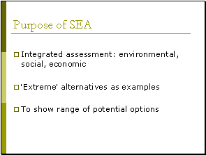
[Slide5] What is the purpose of SEA? First of all SEA is meant to be an integrated assessment to focus on both the environmental impacts of the plan as well as the social and the economic impacts. Secondly, because of the complexity of the issue it is felt that at this time it is not yet possible to look at realistic alternatives that has to be that has to take place in the next round of spatial planning. This first plan and this first SEA is meant to develop a number of what you could call a number of extreme alternatives; alternatives that are specifically aimed to show the range of potential options. These extreme alternatives, later on I will explain what these alternatives were, are meant to provide insights to planners into public on what potentially could be done. And then what the impacts are. So that in these plans the decisions in principle of where the spatial development of the West of Netherlands should go to can be decided. And then in the next round of spatial planning for which a new SEA will be carried out then the final realistic alternatives will be developed. So this was the purpose of the SEA to be integrated and to show the range of options for the development of this area.
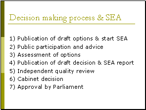
[Slide6] Let me very quickly show you how in this case the strategic environmental assessment was integrated into the planning process. Very roughly it was integrated in the following way. First, two draft options. So two possible developments of this area were published by government and this was the start of the SEA. Then a round of public participation was organized as well as was asked on these two draft options and then on the basis of this round public participation and advise, the final options were defined and assessed. Following that the SEA report was published as well as the draft decision by cabinet. The next step then included an independent quality review of the quality of the SEA. And the institution of which I am adjunct secretary actually carried this out. Then after that the cabinet decision was taken the plan was sent to parliament and there was formal approval by parliament. So what you see here is that the SEA is fully integrated into the planning process. This whole planning process took approximately 1 and half year around. The SEA took about 6 or 7 months. So this was done very quickly.
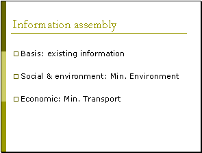
[Slide7] Let me go into the practicalities of the assessment. Where was the information coming from? Who was responsible for doing anything? The first thing, which I would like to say, is that the whole assessment could take place on the basis of existing information. There was no need to start any new research processes the information was readily available. That's why it could be done very quickly. Secondly, the Ministry of Environment was responsible for the social and environmental assessment while the Ministry of Transport was responsible for the economic assessment. Having set these, the two teams responsible for the assessment meet every week discuss what they were doing coordinated and cooperated and of course this is the only way of doing a proper integrated assessment.
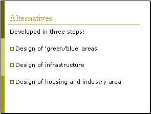
[Slide8] Let me go on the next issue. What kinds of alternatives were developed and how were these developed? Basically, alternatives for these special plans were developed in three steps and right now currently in the Netherlands, this is the basic methodology by which we develop all our spatial plans right now. In a first stage, the green blue areas are designed both existing areas as well as the new areas. So this creates a network of nature areas, recreational areas as well water areas. Within this network of green and blue areas then new infrastructure is projected and designed. So after this stuff there will be a network of green and blue areas and infrastructure and of course within this network then new housing and industrial areas can be designed. Because all these three issues actually relate to each other in order to come to a high quality spatial planning for an area.
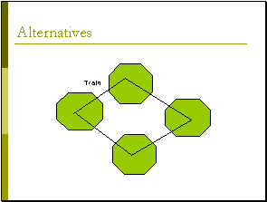
[Silde9] I go back to my very simple map. These are the four cities and this is the valuable landscape area in the middle.
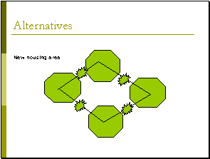
[Slide10] The first alternative that was developed for this area was actually aiming at upgrading the existing railway system connecting the centers of the four cities. So this is a train system right now and the first alternative was aiming at upgrading the train system into a high-speed train system.
[Slide11] Now, of course, you will know that if you create new more effective infrastructure this opens up possibilities for new economic developments. So there will be new industrial areas and housing areas located around the new infrastructure. So for example, in this case in this first alternative that was developed, it was assumed that the new areas probably could be here. Of course from an economic view point this is very effective because you have new housing and industry areas that are very good accessible by high speed train. But of course from an economic viewpoint this is very negative because the new areas are situated in the green belts within the city and these green belts are protected and are highly valued by people.
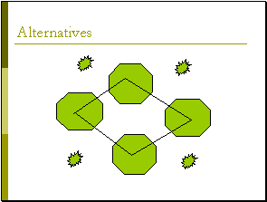
[Slide12] That's why in a second alternative new housing and industrial areas where sought outside of this ring of cities. Economically speaking this is less effective but it might be a lot better for the environment. So this is the second alternative.
[Slide13] The third alternative then was developed during public participation because many local governments had very strong preferences of where new housing and industrial areas should take place. They felt that it should not be national government that selects these locations it should be them. So a third alternative also was based on a high speed train connecting the city centers. But then alternative locations for housing and industry were used that were proposed by local governments and that was a third alternative.
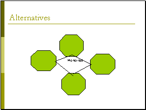
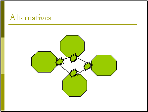
[Slide14]A fourth alternative was completely different. In this fourth alternative, the purpose was not to establish a high-speed train system but to establish a new innovative technique, the monorail. I think here in Japan you have such a magnetic monorail. The advantage of this monorail is that it can reach very high speeds. Another advantage is that it is very prestigious. It attracts a lot of attention from companies all over the world and that of course in itself is good for economic development. However such a monorail and, of course, you know that better than I do is very expensive. So government in the Netherlands felt that this would only be possible if the length of the monorail system would be as short as possible. So in this alternative the monorail would not connect the city centers but it would connect the outer parts of the cities as you see. Of course this new monorail also would generate much new economic development and it was to be expected that new housing and industrial area would be developed around the new monorail system stations and effectively that would be here. Now you can see from this picture that this of course affects the valuable landscape area in the middle of the cities. And of course this is one of the things that SEA should investigate how negative is that. But because of this perceived negative effect a fifth alternative was based on a monorail system but then with housing and industrial areas outside of the rings of cities.
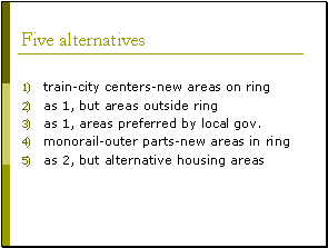
[Slide15] So in summary 5 alternatives were developed and assessed in the SEA. And I summarized them very quickly for you. The first alternative was a high-speed train connecting the city centers with new housing and industrial development along the new ring railway system. The second alternative was the same but with alternative areas outside of the ring of cities to avoid damaging the green belts. And a third alternative was the same train and city centers but new areas for housing and industrial area proposed by local governments. Then the fourth alternative was a monorail system connecting the outer part of the city with new housing and industrial areas on the inside of this monorail ring and finally the same alternative but with alternative housing and industrial area.
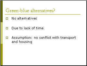
[Slide16] Now, I told you the plan has three elements and these elements alternatives for the green and blue area is not part of these alternatives. That's strange. Why did government decide to do that? Basically, what they said was that we didn't have time. Also they assumed that in the Netherlands there will be no conflict between transport and housing issues and nature and further issues. And these of course then became one of the very important points of attention in the quality review of the SEA report by the independent EIA commission and I will come to that later.
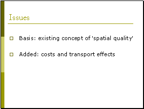
[Slide17] Let's go into the methodology of impact analysis. What issues? Where does it assess in the assessment? Most issues were actually extracted from a concept that was decided at a political level in Netherlands. This is the concept of spatial quality. And since the cabinet has decided that, this should be the basis of spatial planning of the issues where drawn from this concept. I'll come back to that. Two spatial qualities were added cost, economic cost, financial cost and transport effects and these led to an integrated assessment.
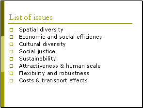
[Slide18] So finally the list of issues against which alternatives were assessed was as follows: what does the alternative do to the spatial diversity in the area? What is the impact of an alternative to economic and social efficiency of the area? And of course this is the main objective of the plan. What does an alternative mean for cultural diversity in the area? What does it mean to social justice the right of minority groups the rights of immigrants? What does it mean in terms of sustainable development? How does an alternative improve the attractiveness and human scale of an area? Because as I already told you, captains of industry of international companies will only live in an area that is attractive. Otherwise they don't show up they don't like to live there. Flexibility and robustness, how flexible is an alternative? How robust is it if the development of the west Netherlands would different than we expect now? And finally cost and transport effects.
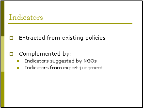
[Slide19] So these were the issues against where alternatives were assessed. For each of this issues appropriate indicators were found. And basically these indicators were found in existing policies and plans. Because it is quite clear that if an existing policy a certain issue is established as important you should have an appropriate indicator for that issue. But, also in public participation the public and NGO's were asked about what the indicators should be and also the academic community was asked what the indicators should be. And from these three sources then the final list of indicator was developed. Now in the time available, clearly, I can't give you all the indicators you will get them in the final research report in a couple of months.
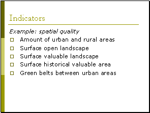
[Slide20] From now but just an example these were the indicators that were found for the issue of spatial quality. Five indicators the first is the amount of urban and rural areas in each of the alternatives, specially the balance between the rural and urban areas. The second is the surface area of open landscape in each of the alternatives. Because Netherlands is, as Japan is, a very densely populated country and we like open landscape a lot. But we don't have much of it. So this is an important indicator as is the surface area of valuable landscape especially because the area within the cities that might be affected by the plan is a valuable landscape area. Of course, the surface area of historical valuable area and finally the effect on the green belts between the cities. So these were the five indicators for the issue of special quality and for all the other issues appropriate indicators were found too.
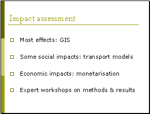
[Slide21] Let's go into the assessment of these indicators what methodology was used? For most indicators a geographic information system was used to find out how an alternative affected the amount of hectares. So the available surface area for functions in that area. So geographic information system was the most important method used here. For some impact including some social impacts transport models were used, so computer models were used for transport effects but also for social effects because the accessibility of the possibility that the new infrastructure creates for minority groups or for people with lesser income to travel from their home to there walk is a very important social impact in an area. New infrastructures should not just be accessible for rich people. It should also be accessible for poor people. And for these transport models were used. For the economic impacts monetarization was a very important method the translation of an effect into money. And finally a very important method was expert workshops. For example, there was an expert workshop on methods to use in the assessment and there was another expert workshop later on the assessment on the validity of the end results. So expert judgment was also a very important method. So these are not listing all methods but these are the most important ones. Of course if you do that you will get a lot of information to give all that information to decision makers and to the public will not be very clear. So if you want to compare alternatives in such a way that decision makers understand it and those citizens understand it, you have to use very effective methodology.
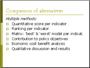
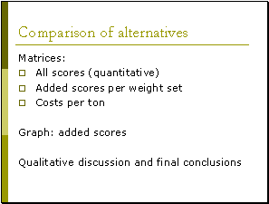
[Slide22] Let me explain to you what methodology was used. First of all they didn't just use one method. They used many different methods to compare alternatives. First of all in those cases where a quantitative assessment had take place, they simply listed all the scores on all indicators. So everybody could look what the scores were. Secondly, for each of the indicators the 5 alternatives were ranked from one to five, which one was the best and which one was the worst. And from this a matrix, one page matrix, was given indicating for each of the indicators, the best and the worst model. This is a very effective way for decision makers to find out which alternative is best which one was worst. But also it was assessed what alternative contributed best to policy objectives. So this was a qualitative discussion, of a contribution of an alternative to policy objectives. So which alternative was the most effective in reaching established objectives? Fifth method was economic cost benefit analysis. So an economic analysis of the cost and benefits, leverage of the alternatives this were listed. And finally and maybe the most important one for the public and decision makers a short qualitative discussion of the end results. What were the most important impacts? What alternative model scored best? And only by using different methods to compare alternatives, all of the different stakeholders group could gain a good insight in how alternatives compare.
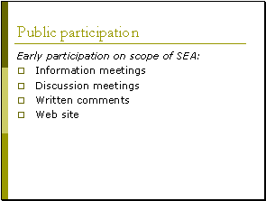
[Slide23] Let's go into methodology for public participation. How do you involve the public in such a large area? Well, first of all I think I've already told you that for favorable participation most of all took place in the early phases of planning. More particularly on the scope of the SEA, and in that stage a number of information meetings were organized, a number of discussion meetings were organized with both NGOs and the general public. Everybody in the Netherlands had the right to send in written commends and a website was established at which everybody at every moment in the planning process could send in comments and these were the main methods used for public participation.
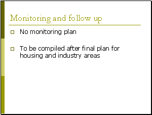
[Slide24] Let's go into a very important part of any SEA, the monitoring plan. Very surprisingly, there was no monitoring plan but if you look at it, it make sense because this realms of various strategic planning was not meant to conclude in a realistic alternative that would be carried out on the ground that would only take place in the next round of planning. So it was decided that a monitoring plan should be compiled after the final plan for housing and industrial areas in the next round of spatial planning was completed. Now let's go to a very interesting question I told you about alternatives. What I told you about methodology now was a good SEA. However is this a good example? Is this an example which perhaps you could follow in Japan?
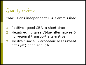
[Slide25] Let me give you some of the main conclusions of the quality review that was carried out by an independent. EIA Commission in Netherlands, they concluded first of all a very positive conclusion. This was indeed a very good SEA. That in a very short time only six months gave sufficient information for both planners and the public to reach a conclusions on the main decisions specially on a decision between a train and a monorail and between the location of new areas on the ring inside the ring or outside of the ring. But there were also criticisms first of all that I told you that the plan and the SEA did not assess alternatives for green and blue areas. Because it was assumed that housing and transport would not create problems for nature and recreation. The independent EIA commission did not believe this to be true. There would be conflicts and they should have assessd alternatives for nature, recreation and water and indeed that would take place in the next round of planning. But also there was a second criticism because the plan and the SEA only focus on improving the public transport system between the main cities, the four main cities, but transport between the main cities is not the most important transport problem in that area because it is relatively easy to go from Amsterdam to Rotterdam. But if you live in a small city or a small village outside one of this big cities it is very difficult to get from the small town and the small village to the big city. So the Dutch EIA commission concluded that there should have been alternatives assessing regional transport too. They were neglected. Finally there was also a neutral conclusion because this was an integrated assessment, and this was relatively new to do a social and economic impact assessment of a special plan on this large scale. The Dutch EIA commission concluded that it had not been done in a very good way there were serious flaws in the method. However the Dutch EIA commission also concluded that this was only logical because the current state of the art in science for social and economic assessment at this level is simply not advanced enough. So was it good enough? No it wasn't. Could it be blame for it? No they couldn't.
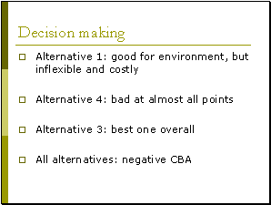
[Slide26] Let's go to the most important topic of all. Was this SEA effective in improving decision-making? And if you ask my personal opinion I would say "yes it was". Because this environmental assessment showed very clearly to the planners what were the advantages and disadvantages of these five alternatives. For example, alternative one, a high-speed train connecting these city centers with new area on the ring, showed to be quite good from an environmental perspective but quite bad from a flexibility perspective and very costly. So this is not a good alternative for the spatial plan. The alternative with the monorail and the new housing area inside the four cities was even worst; this alternative scored bad on all points. The alternative actually that was proposed by local governments actually showed to be the best alternative. So this was a significant contribution of public participation but most important of all, the economic assessment showed that all five alternatives had a very negative cost benefit analysis. So they cost a lot of money while the economic benefits were very little. And of course this was a great concern to the government.
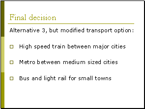
[Slide27] Now what happens because, as we say, the "proof of the pudding is in the eating" what did government do with this results. Well, what they decided was that alternative three, a high speed train connecting the city centers with housing and industrial areas, preferred by local authorities, should be the basis for a new round of planning. At the same time they concluded that just to improve the transport system between the main cities is not enough. So they choose for alternative three but with modified transport options. So should there be a high-speed train between major cities? Yes, there should be. But there should also be a system between medium size and there should be improved bus and light rail system for small towns. Affectively, what this mean is don't spend all your money on the high-speed train but save considerable budget for bus and light rail. I would say that there is considerable influence of the results of the SEA in this decision.
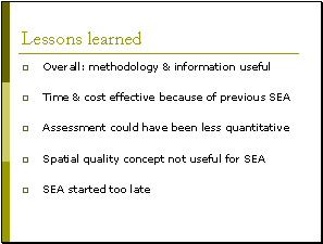
[Slide28] I will conclude this part of my presentation by giving you some lessons learned not all of them but some of them that I think it's significant. First of all, overall the methodology that was applied and the information that was developed were very useful for strategic decision making. Secondly, the SEA was developed in a very time and cost effective way. When I discuss this with the people in the Ministries, they said this was mainly because an SEA had already been carried out for the previous spatial plan for the west of the Netherlands, and everything that was learned then was used now. So here you see a significant learning effect. If you do SEA for the first time it will probably cost you a lot of money and time. If you do it for the second time it will be a lot more time and cost effective. Thirdly, although the methodology and principle was very effective, government felt that many issues could have been assessed much more qualitatively. So, a geographic information system, you don't need for all the indicators. Often expert judgment would have been enough. Just common sense would have showed which alternative was best. Also, this political concept of spatial quality may be useful for political decision-making. But it is not useful for assessment because it leads to too many indicators and too much overlap between indicators. And the most important conclusion was that the SEA had started too late because public participation only took place after the first two draft policy alternatives had been developed and it was felt that it would have been more effective to have public participation even before that on problem analysis and objective setting. Also, if the SEA had started earlier, there could have been public participation at more than one stage in the planning process. So next time, they will try to start earlier. This more or less concludes my first presentation. And because you already have a lot of information now, I will just give you one minute now to relax and I drink a glass of water. I am not quite sure if this was one minute but looking at the time, I think I should continue.
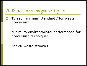
[Slide29] Let's go to the second case study. The 2002 Waste Management Plan, actually, this plan was developed in 2001 and 2002 and only last month it was finally adopted. So this is very recent. I will not go into all details of this SEA in this plan process. I will only highlight some aspects of it. First of all, what is the purpose of this plan. Well, this plan has a number of purposes. But I will focus here on one purpose. This National Waste Management Plan should set in the Netherlands so-called minimum standards for waste processing. What I mean by that is that a minimum standard defines the minimum environmental process that minimum environmental performance for a particular processing of a particular waste stream. So for example, if you are a waste processing company and you want to have a license for a new innovative processing technique, you have to prove that your technique actually scores better on environmental issues than the minimum standard in the national plan. This is how waste management planning in the Netherlands works. These minimum standards should be defined for 26 different waste streams. Very diverse waste streams, waste oil, batteries, photographic materials, and so on.
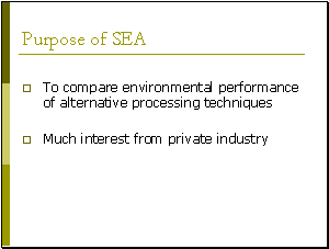
[Slide30] The purpose of the SEA was to compare the environmental performance of the existing alternative processing techniques to make it possible for decision makers then to decide what should be a realistic minimum standard for practice. So this was the purpose of the SEA, to compare alternative techniques. But there was also a second purpose for the SEA. Because you can imagine that if private industry is so heavily influenced by a plan, there will be a lot of interest in that plan. Because it may considerably influence on the economic performance of a company. And also waste processing is very controversial in the eyes of a major part in the general public. Nobody likes to live near a waste processing facility. So this is a controversial plan. It will only be accepted if it is a credible plan. The SEA was meant to improve this credibility. And that was a second purpose of the SEA.
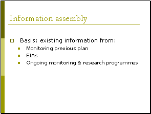
[Slide31] Let me go into information assembly. First of all again, the SEA could be carried out on the basis of existing information. And again this SEA was carried out quite quickly because existing information was available for monitoring, the previous waste management plan from the EIAs for concrete projects as well as out of many ongoing research monitoring research programs in the Netherlands. So existing information was available. Many, many data were available.
Skip [Slide32].
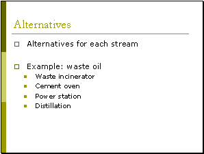
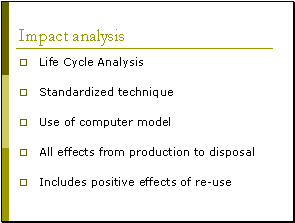
[Silde33] What method was used to compare and assess alternatives? And here we find a very interesting methodology. It's the methodology of Life-Cycle Analysis. Life-cycle analysis was developed for use at the project level. It's a very sophisticated way of assessing environmental issues. It is a standardized technique and it uses a computer model. However, it was felt by government that they could use Life-Cycle Analysis in this case because so many data were available. And Life-Cycle Analysis needs a lot of quantitative data. Now it was decided to use Life-Cycle Analysis because of the advantages of this methodology. And the most important advantage is that it doesn't just look at emissions, direct emissions of waste processing. It looks at all the impacts, from cradle to grave, from production of the waste, to processing of the waste, to reuse of the final residue. And this is important, because in waste management, one of the lessons learned in the Netherlands is that the positive effect of reuse from waste are very significant. They are actually more significant in policy making than the direct negative effect. I already told you that Life-Cycle Analysis is a standardized system of environmental assessment. It has been developed in many countries in parallel including in the Netherlands, including in the United States.
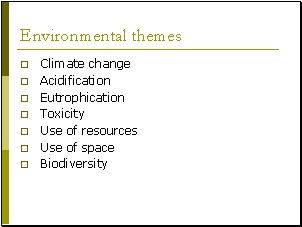
[Slide34] Let me give you an overview of the most important environmental themes against which alternative techniques are assessed. First of all, effect on the climate change. Second, effect on acidification. Third, effect on eutrophication, both on the water systems and the land systems. Fourth, toxicity, both for humans as well as for eco-systems. Fifth, use of resources. What does a waste processing technique means in use of energy, use of water, use of metals, and so on? Use of space is a very important issue in the Netherlands because it is so densely populated and I would assume in Japan the problem is even more important. And finally, biodiversity.
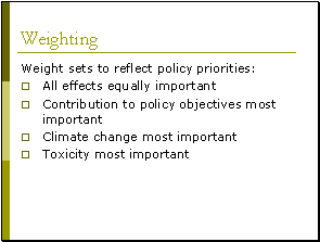
[Slide35] So these were the issues against which the alternative processing techniques were assessed. In Life-Cycle Analysis, the individual scores on each of these themes are then calculated into one final score. Of course you will understand that that final score will be very heavily influenced by how important you find this one or two or more of these themes. For example, if you think climate change is the most important issue, you will get another final score than if you think all the issues are all equally important. And for this reason, an important part of this methodology is to use different weightings of these environmental themes. And I would like to discuss the environmental weight sets that were used in this case. The weight sets were selected to reflect policy priorities. The first weight sets actually assumed that all effects were equally important. So all issues, all environmental themes have the same importance. A second weights set actually took another approach because not all these environmental themes will be equally influenced by waste processing. For example, use of space is highly influenced by waste processing. But toxicity is very heavily influenced by waste processing. So in these specific weight sets, those issues, those themes that were most influenced by waste processing were given the biggest weight. And the other environmental themes were given less weight. And this, of course, leads to another end result. A third weight sets reflects the importance that the Dutch national government gives to climate change. So in these weight sets, climate change gets the most weight while the other themes get less weight. But in the eyes of the general public, not climate change is the most important but toxicity is. How does waste processing actually affect my health and the health of my children? So a specific weight sets was developed for that too in which toxicity was given the most weight. Then, using all these four different sets, final scores were calculated and the end results were discussed so that decision makers and the public could see what the results were in each of these cases.
I will skip this one [Slide36].
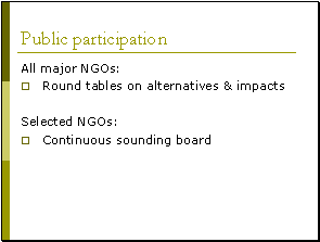
[Slide37] I will go into the issue of public participation. Because I already told you that this plan was very controversial. If you want to improve the credibility of a plan, you need to have very effective public participation as part of plan preparation. Now, what did they do in practice? First of all, they applied different methods for different stakeholders. For example, all major NGOs interested in waste processing in the Netherlands, including industry, were invited for a number of round-tables to discuss the alternatives that should be assessed as well as the impacts that were most important. A selection out of this group of NGOs was then asked to be part of a sounding board, a group of NGOs that was continuously consulted all through the planning process and the assessment. So they played a very significant role.
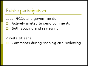
[Slide38] A third group that was distinguished was the local NGOs and the local governments. What did they think about waste processing? And they were very actively invited to send in comments and by active, I mean, by direct mail. And they were invited to send in comments both during scoping in an early stage and reviewing at a later stage. And the general public then was given the right to send in comments whenever they wanted during the scoping and reviewing.
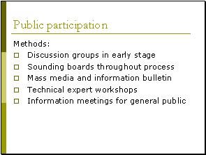
[Slide39] Now, was this an effective way of doing it? First of all, in summary, these were the methods that were used for public participation in this case. Discussion groups were organized in an early stage. Sounding boards were created that were consulted throughout the process. Mass media and information bulletins were used to inform the public throughout the process. For technical experts, both from government, from academic institutions and from NGOs were invited for workshops. And there were information meetings for the general public.
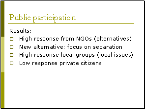
[Slide40] This was an oversight of the methods used. And was this effective? How did the public respond to this methodology? Well, first of all, there was a very high response from NGOs, both from environmental NGOs and NGOs from the industry. Most of these comments focused on alternatives so this was very useful for the plan. And actually, it brought into the decision-making process a new alternative that previously the government had not given a lot of attention to. And for those of you that are waste experts, this is an alternative in which you focus on separation of waste before you process it. There was also a very high response by local groups, local NGOs, local politicians and local governments. However, their comments mainly focused on local issues related to waste processing. And that did not prove to be very useful for strategic planning at the national level. However, it did give very valuable information for the next level of planning, the more concrete level. And finally, there was a very low response from private citizens. So it seems that the general public is not really very interested in these sorts of strategic plans in the Netherlands.
Skip [Slide 41 to 44].
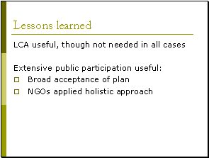
[Slide45] I will go to the end of my presentation. What were lessons learned? First of all, the methodology that was applied, Life-Cycle Analysis was considered as very useful for this kind of strategic planning. However, it proved not to be needed in all cases. For certain alternatives, it would have been enough to rely on expert judgment. Actually, this is exactly the same conclusion as was drawn in the SEA for the spatial plan. Why does it difficult if you can do it easy? Especially the extensive public participation that took place was seen as very useful by planners. Why? Well, most important, it led to a very broad acceptance of the plan.
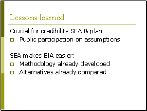
[Slide46] Secondly, it was very good to see that NGOs, applied a holistic approach. So they did not just focus on their specific interests; they looked at all interests. And the reason why it was because they were actively involved throughout the planning process. So they thought with the planners. One of the lessons learned was that if you really want to improve the credibility of assessment and of planning, you should have public participation on the assumptions that you use in assessing impacts. And this has not been taken place in this case. So this is one of my colleagues in the department that tells me that next time they will also consult the public on what assumptions to use. This will improve credibility. And finally, a lesson learned from practice is that this particular SEA will make EIAs for waste processing a lot easier. First of all, because the methodology has already been developed, Life-Cycle Analysis, as it was developed in the strategic level, can be used at the project level, too. And secondly, most alternatives have already been compared. You don't have to do that again at the project level. And this, of course, is one of the very significant advantages of SEA, too. It makes EIA a lot easier. Thank you very much.
Questions and answers:
Question
This is regarding SEA. There are social and economic aspects that are impacted. Is this general? Is it commonly seen that it is not truly environmental assessment but also includes social and economic assessment? However, in decision-making, of course, we do have a more comprehensive input from social and economic aspect. But, is it general or is it seen hardly to have economic and social impact into the SEA, which is an environmental aspect impact analysis?
Answer:
It's not common. If you look at current practice around the world, you will see that in most cases, SEA will focus on the environmental aspects. However, in a number of countries that are more advanced than SEA, you see a trend towards integrated assessment for city plans. Also in developing countries, that currently don't have any system of social or economic impact assessment, you see that if they do an SEA, they will take aboard social and economic impact assessment always. So is it common in developed countries? No. Those countries focus on environmental issues. Is it common in developing countries? Yes it is. The reason for that is that it all depends on the context of a specific country. For example, in the Netherlands, when we started doing SEAs, we had very good assessments in place already for social and for economic assessment. So we didn't need to focus the SEA on that. The SEA should focus on the remaining assessment, the environmental issues that otherwise would be neglected. But in developing countries that don't have an assessment system, or whatever, they take an integrated approach. But even in developed countries, you see currently a trend towards integrated assessment. And the reason for that is that if you want to reach to a conclusion about sustainability of your plan, you need to come up with an integrated approach to economic, social and environmental. But again, most countries that start with the implementation of SEA start with a very clear focus on environmental issues.
Question:
In that case, following the SEA, you have EIA. In that case, do you omit what you have conducted already at SEA in the EIA stage? For instance, you covered the aspects already in SEA, are there any cases which you may skip multiplying and practicing the EIA processing?
Answer:
It is something that has already been done. So if you have already looked at certain alternatives and assessed them properly at the strategic level, you don't have to do it again at the project level.
Question:
I would like to hear your opinion on how the contribution from public participation and in just play in the final decision making if the contributions are of importance and what happens when there is a very negative response from public or NGOs. For example, if there is not in my backyard syndrome or whether the injury is more to cancel this slash projects. Usually, it happens when there is a large infrastructure projects in developing countries. Thank you.
Answer:
Okay, what I hear are two questions. One of them is, is public participation in strategic environmental assessment, does it have any influence? That was the first question if I got it correctly. And the second question is what you do if the public, the broad public is very negative towards the new plan. Let me start with the first one. Is public participation influential? Yes, if you organize it in an effective way in an early stage of planning, then it is effective. Because then you know what the public thinks. You can use the creativity that many NGOs will have and you can take it aboard in political decision making, if you are willing to do that as a government. If as a government you want to ignore the public even if public participation took place, of course, then there will be no influence at all. In the Netherlands, we have a very strong tradition of discussing and listening, discussing with and listening to the public. And in that case, if you have early public participation, it is very influential. But only if you do it the right way, if you have public participation only in the latest stages of planning, then all the major decisions will already have been taken and the influence is practically zero.
Question.
What do you do if the public is very negative? There is not a general answer to that. Because an SEA does not force you to do anything in decision making. Decision making is a political process in which you decide what you do with the information that the SEA gives you. So if the public is very negative about the plan, at least you should know that. So the SEA gives you that information to know that the public is negative. But if your question then is what do you decide, do you do what the public wants or do you do what you want to do in the first place. That's a very difficult question. That depends on the political process. And if a politician does not do what the public wants, it is not the SEA that forces the improvement of this process but then you shouldn't vote for that politician in the next round of elections. So there is a democratic system that makes sure that if the politicians don't do what the public wants, it is changed. But the SEA itself does not force the politicians to do always what the public wants. Politicians take the decision but the SEA gives them the information. If you don't have that information, you don't know what will happen after your plan is adopted. And then you may get very nasty surprises in the implementation phase of the plan. And that can create significant delay as well as cost a lot of money and you might lose all creditability. You need to know beforehand if the public is negative. Please, that would be my answer. This afternoon, we will have a panel discussion. And then my colleagues can also address this sort of issues. |